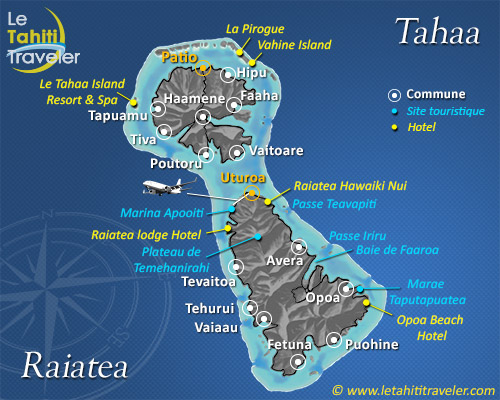
This was a sacred island that was called “Tahaa of the distant marae”. When heroes died in battle they were carried to its shores by canoe whence their soul flew to the original Havai’i of the great “Maori” navigators.

The sister island of Raiatea, enclosed with her in the same wonderful lagoon was not yet the plantation island with the sweet aroma of vanilla pervading the mountains and villages as it is nowadays. But if the growing of the scented pods now plays an important part in the lives of her 4,470 inhabitants, Tahaa, with its 90 km² of charm, has remained the same magic island of the living traditions. A fabulous mountain forms the island’s shape with its peak Mt. Ohiri close to 590 meters. Hidden away under the coconuts and other flower-laden trees a road that is nearly 70 kms in length circles the coastal plain.

Along the way, eight attractive and tranquil villages are dotted, with Patio being the main one. Its lagoon in sapphire and emerald tones -a diver’s and sailor’s paradise- connects